
Underwater Studies at Loch Ness
Unmasking the Topographical Secrets Under the Urquhart Bay
 Sightings of the elusive beast of Loch Ness have been reported for hundreds of years. Sonar contacts also point to the existence of large, moving objects in the loch. What causes the large, animate objects inhabiting Loch Ness to occasionally and partially surface? Could these be statistically predictable, habitual or susceptible to stimulation? If so, could photographic monitoring equipment be put in the right place at the right time?
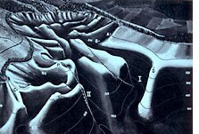
In 1971, a scientific team from the Academy of Applied Science was determined to answer these questions by uncovering the unusual bottom topography under Urquhart Bay, the scene of the most frequent large-object sonar and visual sightings. Armed with this information, they hoped to discover the hiding places and patrolling channels of large animals.
The Goal is Definitive Pictures
To get definitive pictures necessary for a breakthrough discovery, the 1971 Academy team employed both the surface cameras of the LNI team and their own Edgerton elapsed-time underwater flash camera.
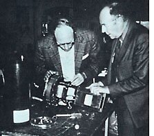 The Edgerton camera was contributed by then Academy Member Professor Harold E. Edgerton of the Massachusetts Institute of Technology, the renowned inventor of electronic flash stroboscopy and photography, and "Papa Flash" to Jacques Cousteau's many readers.
But where to put the underwater camera, with its limited range, in the peat-stained water of the Ness remained the pressing question? That was the task of sonar, the team's submersible "eyes." The sonar would provide the needed data to build maps of the bay's underwater real estate, giving a clearer idea of where large animals objects might hide, patrol and feed. For example, if these very large beasts do patrol the bay, how can they get into the shallow end where the salmon seek the river mouth, without more frequent detection of their expected surface disturbances? What schedule do they follow and which routes do they take?
Using the sonar tools at their disposal, the Academy team began to scientifically pinpoint high probability underwater sites for future monitoring. Numerous transverse, longitudinal, and crisscross bottom profiles were recorded, extrapolated, and then plotted. And lo, the mystery of the bay started to unlock! Bordering both sides of the bay were steeply sloping deep ravines that then climbed to more shallow shores. It is along these deep ravines, in parts several hundreds of feet deep, that large creatures could well patrol the bay - even almost to the river mouth, where the team found an unexpectedly steep drop - and they could frolic in this activity without ever breaking the surface!
The known underwater sonar contacts and the visual sightings could now be referenced to the newly-revealed topography. Understanding sparkled! A photo-recorded surface sighting (McNab) corresponded to a newly-mapped series of relatively shallow ridges extending outward from the location of the Castle. Another visual sighting by Academy members in 1971 corresponded to a relatively shallow promontory, suggesting passage upward and over the promontory, resulting in back exposure. The observed subsequent movement of the hump slightly inward of the bay and its rapid sinking is consistent with coming off the ridge into the deep channel discovered there.
Temperature anomalies were also found in these deep channels at substantial depths - only a degree to three and a half degree (F) variation from surface to 250-feet depths and greater; while corresponding measurements a short distance out in the loch indicated an eleven to twelve degree drop over the same depth. These warm channels of water are in the very regions where local residents feel the large creatures may rest, further strengthened by the team's factual correlation between these warm channels and both sonar and visual large-object detection.
The result of the team's work set the stage for a higher probability of success in future experiments and monitoring - no longer would they be randomly shooting in the dark.
Conclusion
Our results in consort with others at Loch Ness have been rewarding, though frustrating in view of the limited time we have been able to devote to continued effort, the hostility of the environment, and the problem itself.
Until adequate photographic results or higher definition sonar imaging has evolved, identification of the moving objects under the loch will not be possible.
Even were there not the growing wealth of surface and subsurface pictures and observations by reliable persons, the consistency of sonar tracking to date removes all doubt as to the continued presence of large, moving underwater animals in Loch Ness.